Metro Zone: Fare control on Septa

In the previous article “Fair Control,” I introduced the concept of enacting Fare control on Regional Rail/Septa. How exactly would that work?

Abstract: All regional rail stations within a designated urban movement area (aka Metro Zone) are to be made compatible with the fare control procedures on the subway.

Method:

  1. Regional Rail stations within the designated urban movement zone will be retrofitted with turn styles made to accept tokens and fare cards.
  2. Customers will be able to enter all stations within the Metro Zone by using a token. Tickets will be checked upon departure outbound from the Metro limit. Outbound fares will be adjusted accordingly, as travelers from the city to the suburbs will have already paid a token to enter the system.
  3. Inbound fares will include the value of a token.

Announcements will be made on the trains prior to reaching a station at the limit of the Metro Zone, informing customers that they must depart here if they do not possess a ticket, or means to pay the additional fare. When the train stops, the announcement is repeated, and platform times are doubled at such metro limit stations. Conductors clear the platform and shout all aboard prior to departure when outbound.

To meet the minimum frequency requirements of the Metro Zone, to make these lines reliable for non regimented travel, some trains will simply reverse direction when reaching the metro limit, rather than continuing on their suburban service. System wide improvements in automation, and if appropriate, a reduction in the number of cars per train will be necessary to reduce headway on all legacy services.

Any Metro stations outside the metro zone will require the payment of additional fare to enter the station, or when exiting, for outbound trips. In the current plan revision, the only such stations are Manayunk, and those along a remote section of Roosevelt Boulevard.

Ultimately, it may be beneficial to include the entire regional rail network in the fare control system, to reduce  personnel costs associated with collecting tickets. It remains to be determined however, exactly how much regional rail customers ought to pay for their commutes. On one hand, those living outside the city limits should be required to pay in user fees what they don’t contribute in taxes. On the other hand, to reduce car traffic in the city, costs should remain as competitive as possible. The spend-cap system described in the previous article is a critical component in this strategy, as the psychological consideration of ridership is shifted from a cost-per-trip mentality to one of increased-value-per-use.

The other avenue to consider, is incentivizing suburban vehicle owners not to drive into the city with them by way of reciprocal tax agreements with outlying municipalities, or more simply, by creating disincentives in the form of reduced vehicular access (center city car free zone,) and/or increased costs. The price of parking at the new inter-modal centers will influence this, and additional tolling at city portals and crucial points of congestion should be considered.

Of course, suburbanites will always want, and need, to own cars. The objective is not to discourage vehicle ownership, but to make ridership more attractive to those that are going to invest in a personal vehicle regardless.

Fairmount Project

Belmont Plateu overlooking Philadelphia, Fairmount Park
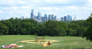
Philadelphia lays claim to what is oft boasted the largest urban park in the world, or the largest landscaped park in the world. These claims of course allude to Fairmount park, or the conglomerate Fairmount park system. Fewer claims however, have been that Fairmount Park is the best park in the world. In this series, we will explore Fairmount’s assets and design, its historical intentions and its current state of disrepair. Through these lenses will come a series of proposals by which Fairmount may yet become the world’s finest urban park.

Fairmount today is a large swath of territory that does not function as a single cohesive park. Instead, it is more like a region with scattered attractions and disjointed segments of trails and open space. Some key points of focus will be:

  • Reduce the functional deficiencies and hazards presented by the overpopulation of roads within the park.
  • Map the official and ad-hoc trail network within the park, and blaze connections between them.
  • Examine usage of large spaces, including sports and open fields, and consider alternatives
  • Unifying the park’s privately managed attractions for universal access
  • Consider new public attractions and facilities
  • Provide improved access to the park with transit, pedestrian, and bicycle-oriented design.

In the next article, we will examine the Origins of Fairmount park, and how its historical context may be attributed to present-day deficiencies.

The Refinery Redevelopment

Following the disaster at the Philadelphia Energy Solutions refinery, there was a public movement to redevelop the site for a modern, renewable form of energy generation for the city.

The refinery site sits on about 1300 acres- approximately the size of center city itself (Spring garden to South st, river to river)

What can be done with the site? Some have suggested a solar energy farm. Given at face value that the electrical needs of an average household require approximately .032 acres, napkin math would indicate that the site could provide electricity for about 40,000 households. Sounds like a lot, but that’s only about 6.5 percent of city. (Diving the population by the average household size) Considering the refinery used to supply most of the gas for the northeastern US, that doesn’t seem very efficient.

A biofuels company has stepped into the fray in a bid to purchase the site. What benefit would this truly have to the city? How many jobs would be created/restored? What would the tax revenue look like? These questions are hard to answer, but Occam’s razor would suggest such a conversion would be guided by two basic aims: to minimize the initial conversion, and to minimize future operating costs. The later would suggest that automation would be employed to reduce the necessary workforce, and thus the number of jobs that would be restored. The former would suggest that as much existing equipment would be used as is practical, which would result in an environmental impact similar to that of the former operation.

The economic benefit of industry is partially realized by the jobs it supports, but also by tax revenue. It follows then that taxation should be maximized in order to spread the benefit, and offset the environmental penalty of industrial use. The location of the site and its proximity to navigable rivers and its central location within the northeastern region makes it uniquely well suited to the industry it has historically supported. At the same time, its relatively isolated position in the context of the Philadelphia urban area, leaves it not particularly well suited to redevelopment as commercial, residential, or park land development- the need for abatement of its polluted ground further discourages this possibility.

I would have to conclude that the most logical use of the site would be to restore its industrial use as a refinery for fuels- but to ensure that the city seizes the opportunity provided by the change in ownership to enact tighter environmental regulations, to minimize or prohibit entirely the discharge of industrial byproducts into the Schuylkill river.


Fair Control

The proposed transportation network described on this website requires a fare control regime that encourages ridership.

While I am a fan of fare free transit, this would most likely only be made possible through a high level of taxation. This would unfairly subsidize suburban living by placing the cost basis exclusively on city residents. This could be partially corrected by user fees at the inter-modal parking facilities, by providing discounts there to vehicles registered in the city and drivers with licenses bearing a city address.

What I do propose is fare system that includes a per trip fee, along with spending caps on a rolling 7, 30, and 365 day basis.

For example, if the base fare is $2, the daily limit is $6 (3 times the base fare), the 7 day rate is $20 (10 times the base fare), the 30 day rate is $60 (30 times the base fare), and the annual rate is $500 (250 times the base fare.)

At each swipe the system will look back to see if a spending cap has been met and if it has, no fare will be assessed.

Passenger A commutes 5 days per week by train, after 5 days he will have met the weekly cap. When he accesses the transit system on the weekend he will not be charged. On Monday, he is charged when he goes to work but after he gets home he takes the train to go shopping, he will not be charged because the 7 day rolling total has been met. After three weeks of similar usage the “monthly” (30 day rolling) limit will have been met and fees will be assessed until the system looks back and sees less than $60 spent in the preceding 30 days.

A similar formula would be used for fares on regional rail, extended to account for trips to different zones. For example, consider a rider that has hit the weekly fare cap commuting to work from the fare zone in his town. On Saturday, they travel to center city to do some shopping during the day, before taking regional rail to meet a friend in a further suburb a more expensive fare zone from that in which they live. This rider will be charged only the difference in fare between a ride to their home zone to their friend’s zone.

This system removes the complexity and stress of budgeting from the rider and assured that they are always paying the lowest rate possible, and reduces the access disadvantage to those lacking the means or foresight to prepay.

Philly Transit Project: Plan

To transform Philadelphia into a transit oriented city is a massive undertaking, but while New York is choking on its own infrastructure as its employers and residents flee the rising cost of doing business there, now is the time for Philadelphia to make itself.

The vision for a new Transit Authority of Philadelphia will be realized upon completion of these initial phases.

  • Phase 1 – Design a Transit Network with a declared scope and committed level of service, as well as an financial and administrative paradigm to allow the system to sustain itself.
  • Phase 2 – Establish a uniform fare control within the designated City Transit Zone.
  • Phase 3 – Utilize existing track and rights of way to establish 3 new metro services within the Central Transit Zone.
  • Phase 4 – Improve the tunnels under market street to accommodate new services, realign station stops to connect with new loop services.
  • Phase 5 – Construct new tunnels for two new metro services along 5th St and Ridge & Allegheny Avenues, and complete the delivery loop.
  • Phase 6 – Dig tunnels for an outer delivery loop, redirect PATCO service to terminate at City Hall. Realign I-76 through a new tunnel under Belmont Ave. Construct central parking garages along the outer loop area and at other inter modal hubs.
  • Phase 7 – Dig tunnels for a subway on 28th St via the unused tunnels under Pennsylvania Avenue.
  • Phase 6 – Establish streetcar lines to fill in gaps in metro service (Supplemental) and deliver people from stations in residential areas (Last Mile).
  • Phase 8 – Extend the Market-Frankford Line to Northeast Philadelphia Airport and realign stations along the route to connect with intersecting services.
  • Phase 9 – Close access to the area within the outer loop to other than emergency vehicles except along Broad Street and I-76. Discontinue bus services made redundant by the metro system

Check back in the coming weeks while I discuss each of these phases in depth.

Philly Transit Project: Brief

Philadelphia is, and has been, a car city for a long time. Once upon a time, it was a streetcar city, with PCC trolleys running up and down just about every street in town.

Deindustrialization hit Philly hard, by 1990 population was down 25% from its historic peak of the 1950s and 60s, and it has remained down since. Redlining, White Flight, and disinvestment hurt the city in a way that it has only just started to recover from.

With economic recession and dwindling population, there is no mystery as to the lack of investment in the city’s transit infrastructure. As the car culture came into its heyday, transit became associated with low class and undesirable neighborhoods. As the social isolation of the suburbs has been compounded with that of the internet culture, the value of cities in quality of life has been rediscovered.

The novelty and expensive burden of personal vehicle ownership has grown stale in the eyes of many, yet there remains an inexorable truth: If transit does not meet ~95% of one’s transportation needs, one must own a car. It then follows that if one owns a car, they would be unlikely to utilize transit as they already bear the fixed cost of vehicle ownership, doing so would only be economical when parking at the destination is prohibitively expensive or impossible.

If transit serves 95% of one’s transit needs, and one need only use a taxi or car share once or twice a month, then it is uneconomical to own a car.

So, let’s design a transit system that meets 95% of transportation needs for 95% of the city’s residents.

In Transit: EZ Metros

In the last bit I wrote about the plan for a new subway in south philly using mostly existing rights of way, but how about two new services for North and West Philadelphia that run entirely on existing rights of way?

Mantua, Brewerytown, Strawberry Mansion, Stanton, Fairhill, Juniata, what do all these neighborhoods have in common?

Not that they are all rough neighborhoods.

They are all situated along train tracks, but have no train stations.

What if stations?

Screen Shot 2016-05-19 at 2.55.39 PM

Two new metro services on existing tracks. The yellow line is currently in service for Amtrak and SEPTA routes, the right of way is four tracks wide and could easily accommodate additional Metro service with improvements to switching infrastructure.

The blue line does not currently see passenger service of any kind, and on the surface, seems less useful than the yellow line, it has several unique benefits.

The station in Brewerytown will make a huge difference in traffic on 76 by keeping nearby residents off the roads.

The far reaches of the line cutting through Kensington and Port Richmond carry passengers to and from the Frankford El, encouraging transit use in winter months when long walks encourage people to use cars.

The middle section connects the BSS and the MFL, making the system more multi-dimensional. The blue becomes more and more useful as the transit system develops towards a state of grid integrity.

Perhaps the greatest benefits of the EZ metro will be social ones. Both lines serve gentrifying and blighted neighborhoods alike. By expanding mobility you expand the horizons of the cities poorest residents and expand their opportunities to access employment and education.

Whether or not you care about the well being of the city’s poor, raising the bar for the lowest standard of living just a bit will do good to stem the tide of violence that has plagued the city for so long, which will serve to revitalize the city’s urban experience and metropolitanism by quelling the culture of fear that has perpetuated the cyclic decay of the 20th century.

In Transit: 25th St El

Grey’s Ferry This is where the plan begins.

Screen Shot 2016-05-19 at 11.08.23 AM

I used to live in Point Breeze, before moving to Philly I thought a walk from 19th st to Broad st to get on the subway would be an everyday occurrence. I was wrong for a few reasons. First of all, I have a car and a bicycle, so despite my affinity for transit and preference to use it when possible, the subways themselves are not so useful, and transit in Philadelphia really means buses, which are slow and unpredictable and its generally agreed, they just suck. The bus sucks. Everyone knows it.

Besides being noisy and polluting, they are less reliable than rail transit and subject to traffic and stops meaning a private car is invariably faster (unless its stuck behind a bus, then they can be tied. But a determined driver can usually get around one, even by going up a block if neccessary) .

To native Philadelphians that all may seem like common logic, but back in NYC and in many other more populated and/or more developed cities, the primarily grade separated transit system is often much faster than personal vehicles, especially at rush hour.

Grey’s ferry is close to center city, yet it is so far. Despite being a stone’s throw from one of the country’s major urban centers, the people are largely dependent on cars, and those that cannot afford cars have punishing commutes on buses (if you ask me, any commute that involves a bus is punishing.)

So what about those tracks on 25th st? All we need is some rolling stock and a few stations, and maybe the structure could take a bit of shoring up as well while they’re at it, but as it stands the tracks serve as a division, an archetypal ‘wrong side of the tracks scenario’ and also a path of blight and underdevelopment along 25th st itself. Transit could instead turn 25th st into an anchor st for the neighborhood’s revitalization, maybe bring some retail, some jobs, less shootings, who knows.

This proposed service would run from Suburban station westbound to 30th st following the existing path of trains bound for University City Septa, diverging from there to cross the rail bridge into south Philadelphia ,stopping at Grey’s Ferry avenue outside Naval Square before turning onto the elevated right of way along 25th st. Southbound along 25th st the service will make local stops before entering the only new right of way along the route, a proposed underground segment along snyder avenue eastbound from 25th, bringing the line to its end at Broad st, with a connection to that line for game day service. North from 25th.

The line is worth building if for no other reason than to provide a direct route for sports fans from 30th st to the stadiums, facilitating the use of transit for Suburbanites and West Philly residents alike. If the connection were built, some septa trains could even be routed directly from the main line to the stadiums, wouldn’t that be nice, main-liners?

So there you have it, the 25th St El.

Roads vs. Rails

Why should Philadelphia, and the United States invest more in rail transit and less in roads?

Because cars, and the infrastructure we’ve built around them, are a disaster. They kill more than 30,000 Americans a year, and maim many times more. They degrade our air quality and contribute to global warming. They are a huge economic burden to the working poor, and the sheer amount of land devoted to storing them has devastated our urban centers and made housing unaffordable.

That is an excerpt from this article which suggest abolishing the interstate highway system altogether. While that may sound radical, he does not actually mean that roads maintenance will cease or that roads will be destroyed, but rather that the system of allocating funds for maintenance is broken, and that highway maintenance should become a state, rather than federal burden. Its not a terrible idea.

If that federal road paving gravy train were to stop paying for infamously wasteful highway projects (think: all those guys standing around doing nothing when you crawl by at 5mph late for work and all that equipment sitting around idle while the road is still closed for the next month) Think about the average construction cost of $25 million per lane-mile. Consider that more oil is utilized each year in maintaining roads than is burned in gas tanks.

Oil is a precious resource, let’s make it go farther by using it in trains. Consider CSX’s claim to move 1 ton of freight 400+ miles on 1 gallon of fuel.  Wonder why our roads are so full of big, relatively inefficient tractor trailers causing a disproportionately high share of traffic and road damage than personal vehicles when we have the largest national rail network in the world.

Consider that it costs $66 billion annually to maintain the interstate highway system, a massive subsidy on automobile travel. Amtrak receives approximately $1.6 billion in subsidy annually, less than 1/40th the subsidy on automobiles. Imagine if the auto manufacturers had to pay to maintain the road system as Amtrak and the freight companies do, and realize how that burden would instantly put the american auto industry asunder.

According to Amtrak’s website, they took in “$3.2 billion in revenue and incurred approximately $4.3” which would indicate a $1.1 billion deficit/subsidy requirement.

If $3.2 billion could be shaved from the budget for the highway system and allocated to Amtrak, tickets could be free.

And if the rest of the burden of highway maintenance were put on to the states, the rest of that money could be loaned to municipalities to build metro systems.

And then we could have roads, which states would need to fund by user fees in fuel taxes, property tax, and/or tolls- or private roads, perhaps funded by some mandated consortium of oil companies and auto manufacturers. Roads with less traffic, less trucks, and less accidents due to less intoxicated drivers, less poor people in improperly maintained vehicles, less people driving who really shouldn’t be but have no other choice, etc.

…And we could have a system of rail transit that is cheaper and faster than driving, which would really make driving pointless for a large percentage of the population. Think PHL -> NYP in 20 minutes. If we had what they have in Japan, that would be our reality. And why shouldn’t we have what Japan has? This is America!